
Þingvellir National Park or Thingvellir National Park is a gorgeous park that is truly one of a kind. Thingvellir has been a national park since 1930. It’s both an important historic place for Icelanders as a geological wonder. Thingvellir is one of the most visited places by tourists in Iceland. The park is located in the south of Iceland. It is one of the 3 most popular tourist attractions on the Golden Circle.
Geology of Þingvellir National Park
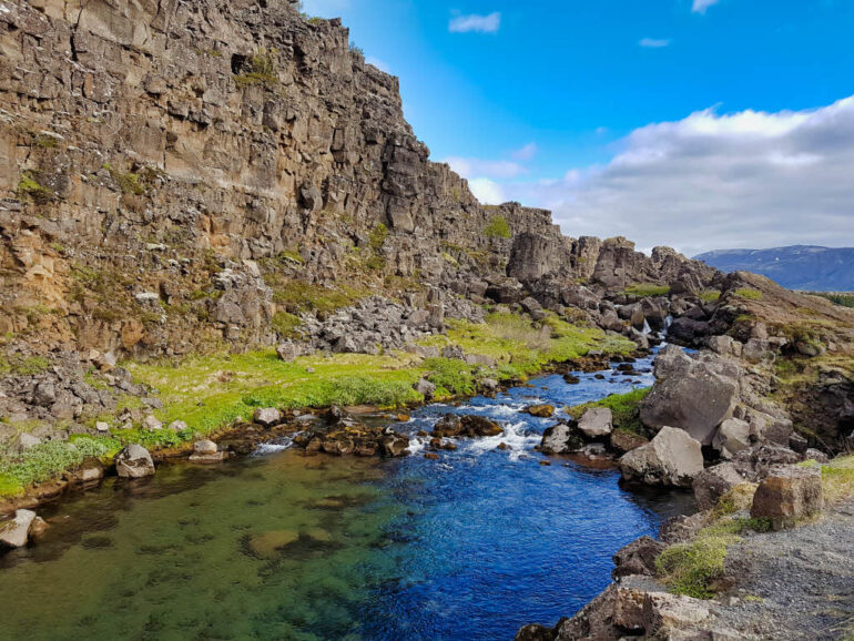
Þingvellir is located on the boundaries of the North American and the Eurasian tectonic plates. Both those plates are moving, causing a ridge in between them. This ridge is called the Mid-Atlantic Ridge. Every year the North American and the Eurasian plates drift apart further. About 2.5 cm (1 inch) a year.
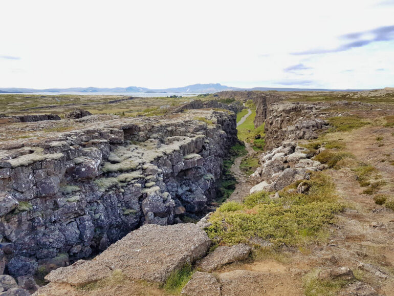
Most of the Mid-Atlantic Ridge is underwater, but in Iceland there are a few locations where the Mid-Atlantic Ridge is above the sea level. Thingvellir is one of those places. The ridge causes geological oddities in this area. Geological faults and fissures have been formed at Þingvellir by the movement of both tectonic plates. When you visit Þingvellir, you can witness this firsthand.
History of Þingvellir National Park
Apart from being a geological wonder, the national park is also a very important place for all of the Icelanders because of its history. Þingvellir used to be the site of the Icelandic Alþing (Althing) from the 10th until the 18th century. The Althing was a yearly open-air gathering of the Icelandic parliament to set laws and settle disputes.
The park also has historic value for other events in Icelandic history. During your visit to Thingvellir, you’ll learn more about them on the signs along the trail. If you want to learn more, there is a lot of information on the official website.
The park’s cultural heritage has put Þingvellir on the map as a UNESCO World Heritage Site since 2004.
Tickets Þingvellir National Park
There are many reasons to fall in love with Iceland. Always being able to pay with your visa is absolutely one of them. When we visited Iceland, we had the feeling like we had been sent to the future. The parking fees are easy to pay and so convenient. You just have to locate a parking machine. Those parking machines are tablets placed around the entrance, restrooms and in the visitor center. On this payment machine, you’ll have to type in your license plate number and pay for the car.
This is easily done with your visa card. When you get out of the parking lot, a camera scans your license plate and checks if you’ve paid for the parking. That system is linked to the Icelandic Transport Authority, so I’d guess if you don’t pay you’ll get a fine. But we didn’t try it though 😉.
We loved this as there are lots of payment machines, so almost never a waiting line and you don’t have to worry about change or anything. You can also pay the parking fee online if you’d prefer that. It’s the same throughout the rest of Iceland, camera systems control paid parking lots and toll tunnels.
The parking fee is the only thing you need to pay for at this National Park if you want to walk around the park. We paid 750 ISK (about €5 / $6). The amount you have to pay depends on how big your car is. Cars with more than 5 seats are slightly more expensive. You can find the up-to-date price list on the official website.
Exhibitions
In the visitor center, there are some exhibitions about Iceland’s nature and cultural history. If you do want to see these exhibitions, you will have to pay an admission fee for that. We skipped the visitor center, so we cannot judge if it’s worth it or not. If you’re interested, you can check the official park website for more information on admission fees.
What to Do in Þingvellir National Park
Þingvellir National Park is one of the only places where the Mid-Atlantic Ridge is above sea-level. You can walk in the valley between the North-American and the Eurasian platonic plates. Knowing that is what makes a visit to this park something to remember! You can enjoy this spectacular national park in many ways such as hiking, diving, and horseback riding.
Hiking in Thingvellir National Park
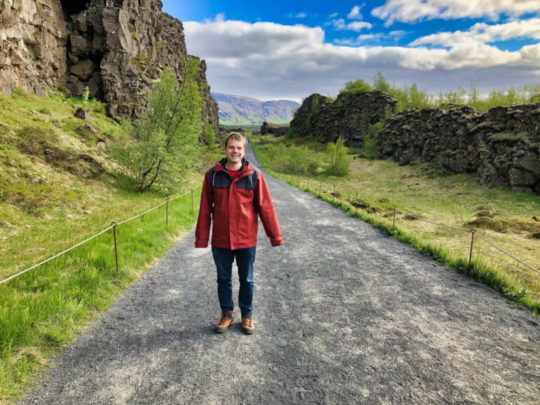
A walk through the fissure zone of the park is breathtaking and to us the best way to fully explore the park. In the visitor center, you can find brochures and park maps so you can choose which trail you would like to follow. The paths are marked and are very easy to follow.
Check out our chapter about our visit to Þingvellir below for more information and a hiking map.
Diving in the Þingvallavatn
Diving is permitted in 2 rifts of the park, Silfra and Davíðsgjá. Silfra is often voted in the top 5 places to dive in the world. The reason for this is that the water in Silfra is so clear, that you have excellent visibility to look at the geological wonders. The water is cold year-round, so that’s why you need to have a certification for diving with a dry-suit. As we’re not divers ourselves, we would recommend you to visit the official website for more information on that.
Our Visit to Þingvellir National Park
This was our first full day of our road trip through Iceland, so we were really excited. We left early and we arrived at the visitor center just before 9 o’clock. We paid for the parking and went straight to the beginning of the hike. Although it was still early, there were already quite some people at the park.
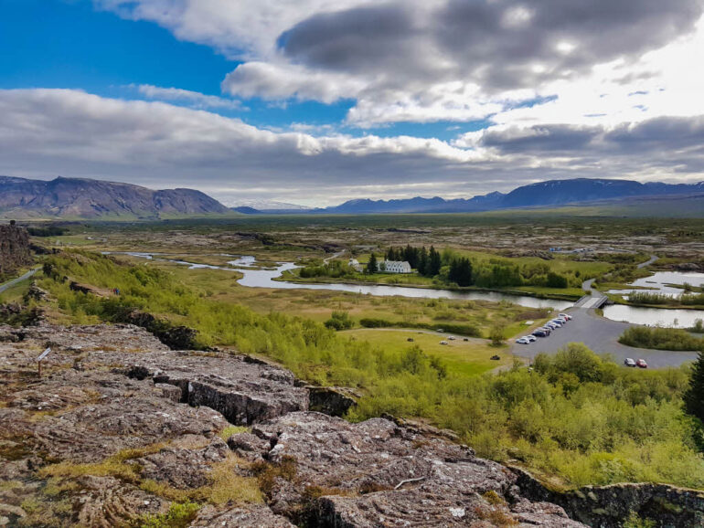
From the visitor center, you immediately walk into the fissure and you need to follow this towards Öxarárfoss waterfall. Along this path, there are many viewpoints where you can admire the Þingvallavatn lake and its surroundings.
Drekkingarhylur (The Drowning Pool)
On the way to the north end of the trail through the park, you’ll see a river flowing, Öxará. Next to the bridge over the Öxará river, you’ll see a pool with a small waterfall in the back. This pool is named Drekkingarhylur. Drekkingarhylur is a deep pool in the river flowing through Þingvellir National Park.
Several 100 years ago, when the court decided someone was guilty on blood shame (incest), this decision making happened in Þingvellir. Men guilty of blood shame were beheaded. Women who were found guilty to blood shame (incest) were drowned in the Drekkingarhylur pool. Similar punishments existed for child murder… That’s why Drekkingarhylur got the nickname “The Drowning Pool”.
Öxarárfoss Waterfall
The highlight of our visit was the Öxarárfoss waterfall. It was our first Icelandic waterfall, so we were really impressed! Who knew that we would see even more breathtaking waterfalls in Iceland. Check out our article Best Waterfalls in Iceland for more information!
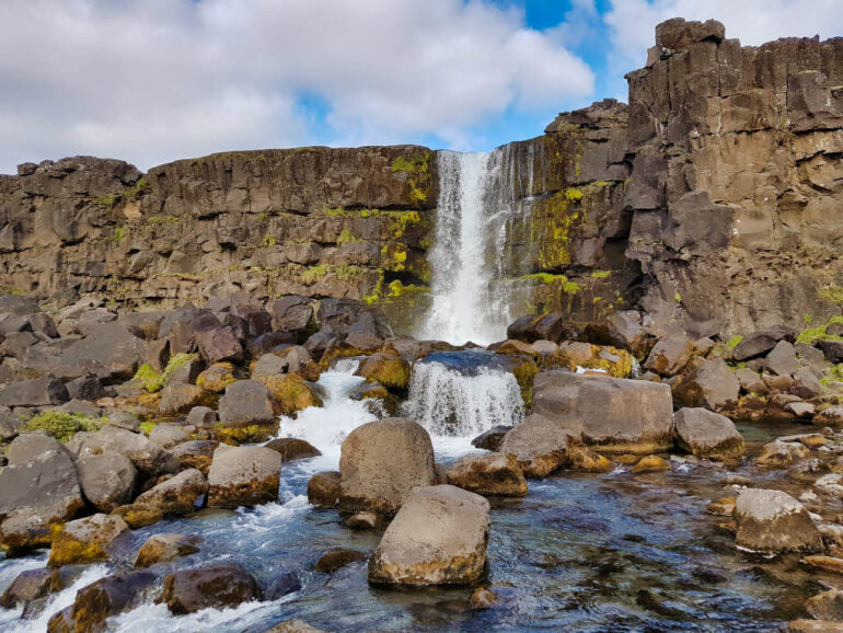
The waterfall Öxaráfoss is a waterfall on the Öxará (Icelandic for Axe River). Öxaráfoss is about 20 meters high. That’s small compared to some other waterfalls in Iceland, but we found it spectacular. The water flows on rocks and below the waterfall, the Axe River continues to flow between the rocks.
One thing we read though was that the waterfall Öxaráfoss is not natural. Geologists discovered that humans moved the flow of the river Öxará to flow into the ravine Almannagjá (source). This way they could provide access to water to the members of the parliament, Alþing (Althing).
Continued Hiking through Thingvellir
After our visit to Öxarárfoss, we decided to leave the touristic trail and hike away from the rift. We hiked towards Skógarkot, the remains of an old farm. This was indeed a less visited area but also a less interesting one. It was a great hike to spot birds, but that’s about it. I would recommend staying on the tourist trail (orange on the map below).
When we were getting closer to the fissures again, we came across the church of Þingvellir called Þingvallakirkja. We crossed some very interesting rifts. One of these, Peningagjá, is filled with water. Because the water is so clear, you can see that at the bottom of this rift, it is full of coins. People throw a coin in the rift for good luck. There were so many coins lying there, that the whole bottom had become shiny!
We got back to our car and drove on. We were going to visit the Reykjadalur Valley in the afternoon!
Þingvellir National Park Map
On the map below you’ll find the parking places of Þingvellir National Park, the points of interest and the hiking trail we did (blue) and the one we recommend you to do if you want to take a shorter hike (orange).
Save Þingvellir National Park for Later
If you liked our guide on Þingvellir National Park, you can support us by sharing our guide on Pinterest or other social media!

This map is a great resource! About how long (either distance or time) do you estimate the “recommended hike” would take?
Thank you for your nice comment :). The recommended tour should take about 1.5 hours to complete.
Would you classify the hike as easy, moderate, or hard? Is it hilly or flat?
Hi Suzanne, thank you for your question. I’d classify the hike as easy to moderate. It’s quite flat, and there is a good path to walk on.
How exciting! Love the history you tell and pictures are lovely.
We plan to travel to Iceland in late August/early September 2022, will we need heavy-warm clothing to hike your trail map? Hey, we’re from Florida, USA, a bit nervous about the ‘cold’.
We are healthy seniors, wondering if Iceland hiking is geared for seniors. We plan to use rental car for transportation. Just might use your blog as our guide.
Thank You!
Hi Linda! Pleasure to meet you and thank you so much for your kind words! So happy you like it! 😄
What a great choice! Iceland is absolutely stunning. We always love knowing the history of the places we visit so we try to be as informational as we can without going too much into details.
Iceland is very unpredictable when it comes to the weather. We were enormously lucky to have a sunny day for our hike. But I’m not gonna lie, the wind can be quite chilly! I’d always recommend to layer up. And a sudden rainfall is always in the cards. But luckily, that counts for the sun as well!
Iceland is a great combination of easy to moderate pathways and interesting more challenging hikes. So I’d say you’ll definitely have the option to see all the beautiful tourist attractions. Especially with a rental car! Some of these paths also have some benches along the way if you’d want to take a break and enjoy the surroundings.
Have fun planning your trip!!
Easy to read, brief and informative. We are visiting Iceland in October to November 2022 and can’t wait enough! Your blog is far better than the others I’ve read. Keep writing, yah?
Hi Eve! Well, your comment just made my day! 😀 We indeed try to keep it as informative as possible. Happy you can notice that!
Enjoy your trip!
Oh how I wish I found this website a few days ago before spending so much time mapping an identical walking route around Thingvellir as the one on this site. Thank you for the information. I now know I have a good plan. I am disabled and use a walker so I’m hoping to make that loop in 2.5 hours.
Hi Kimberly, I’m happy to hear you ended up planning more or less the same hike :). It was a really nice one, so I think you’ll really enjoy it. I do really recommend to hike the orange hike of the map on our website. The blue one has some loose stones. Good luck and enjoy your trip!